Why El Chaltén Is Special
El Chaltén, Argentina's self-proclaimed trekking capital, sits at the northern end of Los Glaciares National Park — 3 hours north of El Calafate on a road through Patagonian steppe. The town of 1,500 people exists almost entirely for trekking, and the concentration of world-class day hikes accessible directly from the village is extraordinary: Laguna de los Tres (Fitz Roy), Laguna Torre (Cerro Torre), and Mirador Cóndor are all reachable without a car, without permits, and without fees. Los Glaciares National Park entry is technically charged but in practice, the trailheads in El Chaltén are accessible without passing any fee collection point. El Chaltén is to Patagonian day hiking what Cusco is to Inca Trail trekking — the indispensable base.
The town was founded as recently as 1985, a deliberate Argentine strategy to establish civilian presence in this disputed border region with Chile. Today, that political origin is invisible — El Chaltén feels purpose-built for outdoor enthusiasts. Every second business is an outdoor gear shop, restaurant, or accommodation aimed at trekkers. The dirt streets, low-rise architecture, and surrounding mountain amphitheater create an atmosphere of serious adventure. This is not a tourist town that happens to have good hiking nearby; it is a hiking town where everything else is secondary.
Fitz Roy Difficulty and Distance
The Laguna de los Tres hike (the primary Fitz Roy viewpoint) is 26km return with approximately 1,200m of total elevation gain, taking 8–10 hours for most hikers. The trail from El Chaltén follows the Río Blanco valley for the first 11km — moderate terrain on a well-maintained path through lenga beech forest. The final 2km to Laguna de los Tres is the crux: a steep 400m ascent on loose scree and rock in approximately 45 minutes–1 hour. The effort is significant and the footing can be challenging, but there is no technical difficulty — it is steep hiking, not climbing. The reward is absolute: a turquoise glacial lake with the Fitz Roy massif (3,405m) rising directly above, its vertical granite towers reflected in the water on calm days.
The trail profile deserves more detail: from El Chaltén to Poincenot Basecamp (10.5km), elevation gain is gradual — roughly 400m over undulating terrain. Most hikers take 2.5-3 hours for this section. Poincenot is the last reliable water source and the point where many trekkers take their major break. The path continues 1.5km to the turnoff for Laguna de los Tres, still on moderate terrain. Then begins the infamous final ascent: 400 vertical meters in less than 2km, much of it on loose scree that provides poor footing. Trekking poles are highly recommended for this section. The descent can be harder on the knees than the ascent — many hikers find the return journey takes nearly as long as the outbound trip.
El Chaltén Argentina Trekking: The Fitz Roy Massif
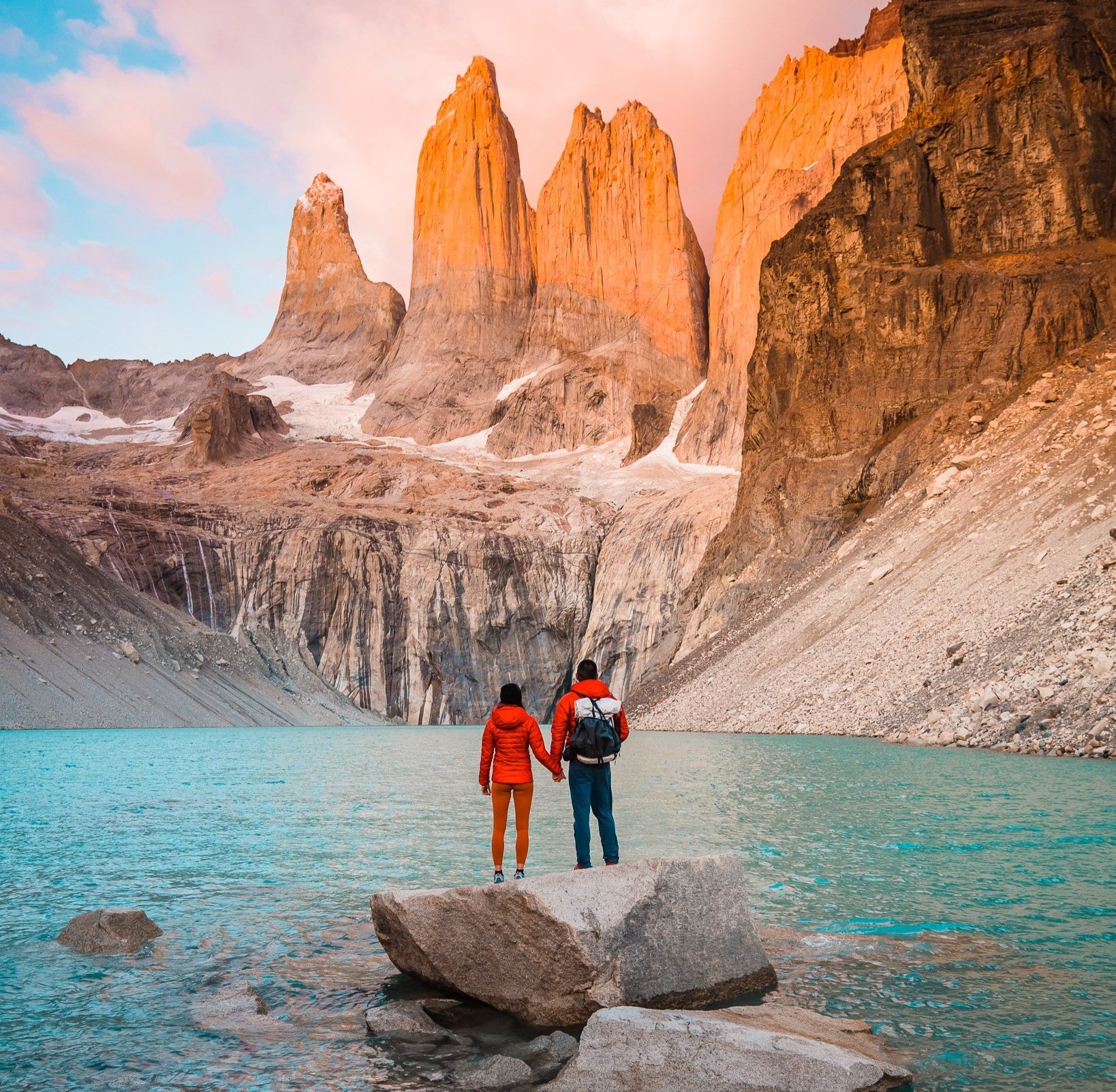
Mount Fitz Roy (Cerro Chaltén in Mapuche — the 'mountain that smokes' for the cloud banner it generates) is one of the most technically challenging peaks in the world. The first ascent was made only in 1952 by French climbers Lionel Terray and Guido Magnone. The adjacent Cerro Torre — a 3,128m needle of granite so vertical that some climbers refused to believe it had been climbed — is visible from Laguna Torre, the second major day hike from El Chaltén (20km return, 6–8 hours). Neither mountain can be climbed by trekkers — they are among the hardest technical climbs in South America. But viewing them from the lagoon at their base, with the reflection and the surrounding icefield, is one of the great mountain experiences available to non-climbers.
The Fitz Roy massif consists of multiple peaks: Fitz Roy itself, plus Aguja Poincenot, Aguja Saint-Exupéry, and Cerro Torre among others. From Laguna de los Tres, the entire spine is visible — a jagged wall of granite that catches and holds clouds in ways that seem to defy physics. The geological story is compelling: these mountains are composed of granite intrusions formed 15 million years ago, then carved by repeated glaciation into the knife-edge ridges visible today. The climbing history is equally fascinating — Cerro Torre was the subject of one of mountaineering's great controversies when Cesare Maestri claimed the first ascent in 1959, using techniques other climbers considered questionable. The mountain wasn't definitively climbed until 1974.
Best Conditions and Timing
El Chaltén trekking season runs November through March. December and January offer the longest daylight (18+ hours) and the most reliable weather — but Patagonian conditions are never guaranteed. The single most important tip: start the Laguna de los Tres hike before 7am. The morning light on Fitz Roy is dramatic from the east (morning sun); by midday, cloud typically builds around the summit. The 4-5am starts that seem extreme at home produce the best photography and the clearest conditions. Park rangers at El Chaltén's Visitor Centre (open from 8am, mandatory registration for all day hikes) have current trail conditions and a very approximate weather forecast.
Weather patterns in El Chaltén are notoriously unpredictable, but understanding the basics helps with planning. Mornings are typically clearest, with cloud building through the day. Wind is a constant factor — gusts of 100km/h are not unusual, and exposed sections of trail can become genuinely dangerous in high wind. Temperature ranges are extreme: summer days can reach 25°C in town, but the lagoon sits at higher elevation where conditions are significantly cooler. Night temperatures regularly drop below freezing even in summer. Snow is possible in any month, though significant accumulation is rare between December and February.
The shoulder seasons (November, March) offer different advantages: fewer crowds, potentially more stable weather windows, but shorter days and higher probability of snow on the upper sections. October and April are possible but challenging — many accommodation and restaurant options close, and trail conditions become unpredictable. The deep winter months (June-September) see the town largely shuttered, with heavy snow making the high-altitude trails impassable.
No Permits Needed
Unlike Torres del Paine (advance refugio bookings required) or the Inca Trail (permits sell out months ahead), El Chaltén's day hike trails require no advance booking, no permits, and no fees. Register at the PNLG Visitor Centre on your way out of town (this is mandatory and takes 5 minutes), receive the trail map, and walk. Wild camping is available at designated sites along the main trails for multi-day itineraries. This accessibility — extraordinary mountain scenery with no logistical barriers — is El Chaltén's greatest advantage over other Patagonian trekking destinations.
The registration process is straightforward but important for safety. Rangers ask basic questions: which trail, expected return time, group size, emergency contact information. They provide current trail conditions, weather updates, and a basic trail map. The maps are adequate for navigation on marked trails, though serious trekkers may want to purchase the detailed Zagier & Urruty topo maps available in town. Rangers track who has returned and will initiate search procedures if groups are significantly overdue — this system has prevented numerous accidents.
What to Pack
Proper gear is essential for the Fitz Roy hike, where conditions can change dramatically within hours. The three-layer system is fundamental: moisture-wicking base layer, insulating mid-layer (fleece or down), and waterproof shell jacket. Even on warm summer days, the upper sections of the trail can be cold, windy, and wet. Waterproof pants are recommended — not just for rain, but for protection against wind and cold on the exposed final ascent to Laguna de los Tres.
Footwear should be sturdy hiking boots with good ankle support. The trail includes stream crossings, loose scree, and potentially muddy sections. Gaiters are useful in wet conditions. Trekking poles make a significant difference on both the ascent and descent of the final steep section. A headlamp is essential for early starts — remember that 5am departures mean walking the first hour in complete darkness.
Pack plenty of food and water. The hike takes 8-10 hours with no services along the route. Carry at least 3 liters of water per person — more in hot weather. There are stream crossing points where water can be refilled, but purification tablets or a filter are recommended. High-energy snacks are essential: the final push to the lagoon is demanding and having easily accessible fuel makes the difference between enjoying the experience and merely surviving it.
Sun protection is often overlooked but critical. The combination of high altitude, reflective snow and ice, and long daylight hours creates intense UV exposure. Sunglasses, sunscreen, and a hat with sun protection are mandatory. A small first aid kit should include blister treatment, pain medication, and elastic bandages for twisted ankles — the most common trekking injuries on loose scree.
Getting Around
El Chaltén is compact and walkable — the town stretches roughly 1km from end to end. All trailheads are accessible on foot from any accommodation. The Laguna de los Tres trailhead begins at the northern edge of town near the PNLG Visitor Centre. No transport is required for day hikes, which is part of El Chaltén's appeal compared to destinations where trailhead access requires expensive transfers.
Getting to El Chaltén requires planning. The nearest airport is El Calafate (220km south), connected by a single paved road that takes 3 hours in good conditions. Rental cars are available in El Calafate, and the drive is straightforward with dramatic scenery — expect to see guanacos, rheas, and spectacular views of Lago Argentino. Car rental is expensive in Patagonia but offers flexibility for exploring the region.
Bus service runs between El Calafate and El Chaltén twice daily during summer, once daily in shoulder season. Taqsa and Cal-Tur operate the route. Tickets cost around $25 USD and should be booked in advance during peak season. The bus ride offers excellent scenery and is comfortable, though the schedule is inflexible. Some travelers choose guided transfers, which cost more but offer wildlife stops and photography opportunities.
Where to Stay and Eat
El Chaltén has a good range of accommodation for its size: hostels from $20/dorm, guesthouses from $80/double, and a few small hotels up to $200/night. Patagonia Hostel and Nothofagus Hotel are consistently well-reviewed. The restaurant scene is remarkably good for a town of 1,500 — Ahonikenk and Techado Negro are local favourites. Book accommodation in advance for December–February; El Chaltén fills completely in high season.
For budget travelers, hostels like Patagonia Hostel and Condor de los Andes offer dormitory accommodation with shared kitchens — essential for preparing trail food and keeping costs down in expensive Patagonia. Mid-range options include Senderos Hostería and Los Cerros del Chaltén, which provide private rooms with breakfast and often have drying rooms for wet gear. High-end accommodations are limited but excellent: Aguas Arriba Lodge and Destino Sur Hotel offer luxury in a rugged setting.
The restaurant scene serves the international trekking community well. Ahonikenk specializes in local Patagonian lamb and offers huge portions ideal for refueling after long hikes. Techado Negro serves pizza and pasta in a cozy atmosphere. Ruca Mahuida offers vegetarian options, which can be hard to find elsewhere in meat-centric Patagonia. Prices are high by Argentine standards — expect to pay $20-30 USD for dinner — but portions are generous and quality is good.
Food shopping is available at several small supermarkets, though selection is limited and prices high. Stock up on trail food in Buenos Aires or El Calafate if possible. The local supermarkets do carry basics: bread, cheese, chorizo, chocolate, and other hiking staples. Several shops sell outdoor gear, though major items should be purchased in Buenos Aires where selection and prices are better.
Practical Tips
ATMs in El Chaltén are unreliable and often out of cash during peak season. Bring sufficient pesos from El Calafate or Buenos Aires. Most accommodations and restaurants accept credit cards, but many shops and services are cash-only. Currency exchange is limited — the official rate applies, which is significantly worse than Buenos Aires blue market rates.
Internet connectivity is generally good in town but non-existent on the trails. Download offline maps and weather forecasts before heading out. WhatsApp and basic email work reliably from most accommodations. Phone coverage extends partway up the main trails but shouldn't be relied upon for emergencies.
Safety considerations are important: weather changes quickly, trails can become dangerous in high winds, and rescue services are limited. Always inform someone of your plans, carry emergency shelter, and be prepared to turn back if conditions deteriorate. The final ascent to Laguna de los Tres becomes genuinely dangerous in high winds — loose scree and exposure make falls likely. Rangers provide current trail conditions, but conditions can change within hours.
Photography enthusiasts should plan for dramatic light changes. The best Fitz Roy shots typically occur in the first two hours after sunrise, when pink alpenglow lights the granite towers. Afternoon light is often harsh and unflattering. Bring lens protection for wind and dust, and consider a polarizing filter for the intense reflections off glacial lakes.